International Project
Due dates have not be given yet.
1. Choose a country of your choice __________________________
2. Okay it with your teacher. You may not choose the United States.
3. Use the outline below to help you as you research. You don’t have to find everything-but use this as a guide.
4. Take notes on index cards having a minimum of 10. Don’t forget to write down your sources for a bibliography/reference page.
5. You will have some class time to do research, but this is an at home project. You can use the Internet, encyclopedias, atlases, nonfiction books, and almanacs. The report does not have to be typed, but must be neat and legible!!
6. When you present your country, you can bring in pictures, souvenirs, flags, post cards, food items, and any other materials related to the country.
I. Physical Description
a. Location
b. Size
c. Population
II. Food
a. Raised (crops)
b. Meals (food they eat)
c. Customs
III. Education
a. Language
b. Different levels- elementary, middle, high, college
IV. Industry
a. Imports
b. Exports
c. Manufacturing- what they make
V. Government
a. Type (democracy, dictatorship, etc.)
b. Leader
VI. Cities
a. Capital
b. Major cities
c. Historical
d. Sea ports/Industrial sites
VII. Waterways
a. Rivers, deltas
b. Lakes
VIII. Natural Resources
a. Vegetation
b. Animals
c. Minerals
IX. Religion
a. Types
b. Special holidays
X. Areas of Interest
a. Sightseeing landmarks
b. Historic sites
XI. Famous People
a. Artists, writers, painters, sports figures, past leaders
Please include an informational bar graph showing a comparison of something that you learned about the country. For example- jobs, religions, imports/exports, etc. Label the graph with a key, title, axis labels, etc. You will need to add color and it must be your work.
You will also need to include a hand drawn map that shows landforms, waterways, surrounding countries, important cities, and the agriculture/natural resources. This map should be colorful, neat, and include a legend.
DO NOT FORGET THE BIBLIOGRAPHY!
South America
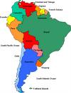
We are currently learning about South America. The people, places, history, and much more. Send in any links you find to help learn more about South America. We will have a test coming up in May.
http://en.wikipedia.org/wiki/South_America
After the South America unit, we will begin a project on a country of your choice. Be thinking about which country you would like to learn more about. It must be a country from Europe or South America.
Current Events- cancelled
Because the Independent Tribune is no longer giving free newspapers to the schools, I am cancelling current events for the months of April and May. March 31st is the last day current events are due!
